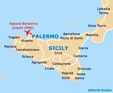
Palermo Airport (PMO)
Orientation and Maps
(Punta Raisi, Italy)
Sicily's busy capital city, Palermo is located on the northern coastline and is edged to the west by the E90 road (Viale Regione Siciliana N. Ovest). An exciting location full of appeal, Palermo is a true fusion of many attractions, including fashion, cuisine and beaches.
Those flying into the region will arrive at the Palermo International Falcone Borsellino Airport (PMO), which is located on the city's north-western outskirts, in the Punta Raisi area. Regular hydrofoils and ferries arrive at the Stazione Marittima docks, which stands off the Via Francesco Crispi, just a short walk from the Piazza Castelnouvo, where you will find Palermo's main tourist information outlet.
Palermo International Falcone Borsellino Airport (PMO) Maps: Important City Districts
The train station in Palermo is known locally as the 'Stazione Centrale' and lies to one side of the Via Roma, while two separate minibus services also run both in and around the city. Palermo's main buses operate from the Via Paolo Balsamo, close to the train station, and travel to every part of the city and beyond.
Historic Palermo contains four main regions, which are centred around the Quattro Canti (four corners). The main districts are the Albergheria and Capo areas - close to the cathedral, the Vucciria area around La Cala Harbour, and La Kalsa - on the eastern side of the city. Notable public squares in Palermo include the Piazza Pretoria, off the Via Maqueda, and the Piazza Bellini, which is close to two impressive churches.
Italy Map

Sicily Map